
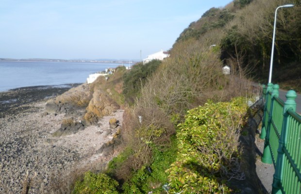
Spring Cove is geographically located on the North Somerset coastline just a few hundred feet to the north-east from the mainland end of Birnbeck Pier. This area is notified as being part of a Site of Special Scientific Interest (SSSI) in two regards, the first of these being that it is located within the wider Severn Estuary SSSI, secondly that it is a site where a very particular and rare geological rock formation can be seen – namely volcanic rock from the Dinantian times, dating from circa 330 to 360 million years ago.
PREVIOUS INTERNET DATA FROM THE ENGLISH NATURE WEBSITE:
COUNTY: AVON SITE NAME: SPRING COVE CLIFFS
DISTRICT: WOODSPRING
Status: Site of Special Scientific Interest (SSSI) notified under Section 28 of the Wildlife and Countryside Act 1981 (as amended).
Local Planning Authority: AVON COUNTY COUNCIL, Woodspring District Council
National Grid Reference: ST 310625 Area: 2.0 (ha.) 4.9 (ac.)
Ordnance Survey Sheet 1:50,000: 182 1:10,000: ST 36 SW
Date Notified (Under 1949 Act): 1952 Date of Last Revision: 1974
Date Notified (Under 1981 Act): 1986 Date of Last Revision: 1991
Other Information: A Geological Conservation Review site. Part of this site lies within the Severn Estuary Site of Special Scientific Interest.
Description and Reasons for Notification: Spring Cove Cliffs are of geological importance because of the stratigraphic and igneous features which are displayed.
The stratigraphical sequence of rock is part of the Burrington Oolite Group (of Arundian age) and provides evidence of localised, penecontemporaneous volcanic activity in mid-Dinantian times. The sections in the Carboniferous Limestone are unusual for the region; they include carbonate and clastic sediments together with basaltic lavas and agglomerates.
Spring Cove Cliffs is a classic locality for the study of volcanic rocks of Early Carboniferous age in southern England. The sequence of Dinantian volcanic rocks, about 18 metres thick, is significant for its southerly position within the Dinantian sequences, lying to the south of the St George’s Land landmass, and also because of the submarine character of the lavas and their intimate relationship with adjacent carbonate sediments. The lava, which is pillowed in places, is believed to have been extruded upon a sloping seafloor. As it flowed downslope it autobrecciated and incorporated blocks of limestone from the underlying substrate.
CNM Estates involvement at Spring Cove
CNM Estates land holdings (previously via CNM Estates (Birnbeck) Ltd but as of January 2021 in the new name of Birnbeck Holdings Ltd) relating to the Birnbeck Pier/Island site overlap to an extent with the Spring Cove SSSI.
North Somerset Council served a Section 77 Dangerous Building notice under the 1984 Building Act on the site’s then-owners, CNM Estates (Birnbeck) Ltd, following the partial collapse of the Birnbeck Pier’s North Jetty during Storm Frank on 30 December 2015, which made the structure a danger to the public.
CNM Estates then engaged in a consultation exercise intended to determine the best way forward to resolve this matter. As a result of these discussions CNM then elected to apply for planning permission to remove the damaged walkway and the five sets of associated supporting trestle legs.
(N.B. It should be noted that this application did not envisage removal of the main off-island landing stage at the far northern end of the walkway.)
This application was made by CNM’s agents, Indigo Planning Limited, on 3 June 2016. This was considered by the North Somerset Council’s Planning and Regulatory Committee on 14 September 2016. The application was then APPROVED subject to conditions and the submission of a satisfactory Habitats Regulations Assessment with no further objection from Natural England. One of the applied conditions stated that the permitted demolition was to be commenced before the expiry of three years from the date of the permission being granted.
On 5 January 2017 CNM Estates’ contractors started work to create a way to get heavy machinery down from the nearby Toll Road to the low-tide causeway leading to Birnbeck Island in preparation for the removal of the Birnbeck’s North Jetty walkway.
They intended doing this by means of creating a crushed rock ‘slope’ or ‘ramp’ down to the level of the foreshore. Some 250 tons of this quarried material was delivered by lorry and then pushed over the cliff edge by means of the use of a mechanical excavator.


Images of CNM’s efforts to create vehicular access to Birnbeck Island.
Questions then arose about whether the correct permissions had been applied for and a ‘stop work’ order was served by NSC on 11 January 2017.
No further action took place with regard to the removal of the North Jetty walkway, and despite calls for the removal of the rock, it remains there as more than something of an unsightly and technically illegal ‘blot on the landscape’ to this present day.
The entire North Jetty is now itself in increasingly poor condition and is likely to suffer further collapsed sections as time goes by. It remains subject to the Listed Building Repairs Notice as issued by NSC on 10 September 2019.
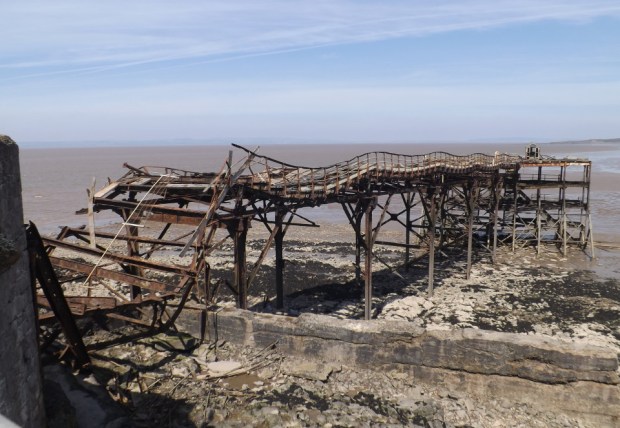
The North Jetty as seen in April 2021.
Meanwhile, if you’re concerned about potential loss to Weston’s character and appearance, as well as the significant contribution that excessive and poorly considered overdevelopment makes to climate change, please contact us:
Please use our contact page here: (Link)

Click here to return to our Home page
© 2022 Birnbeck Conservation Group
